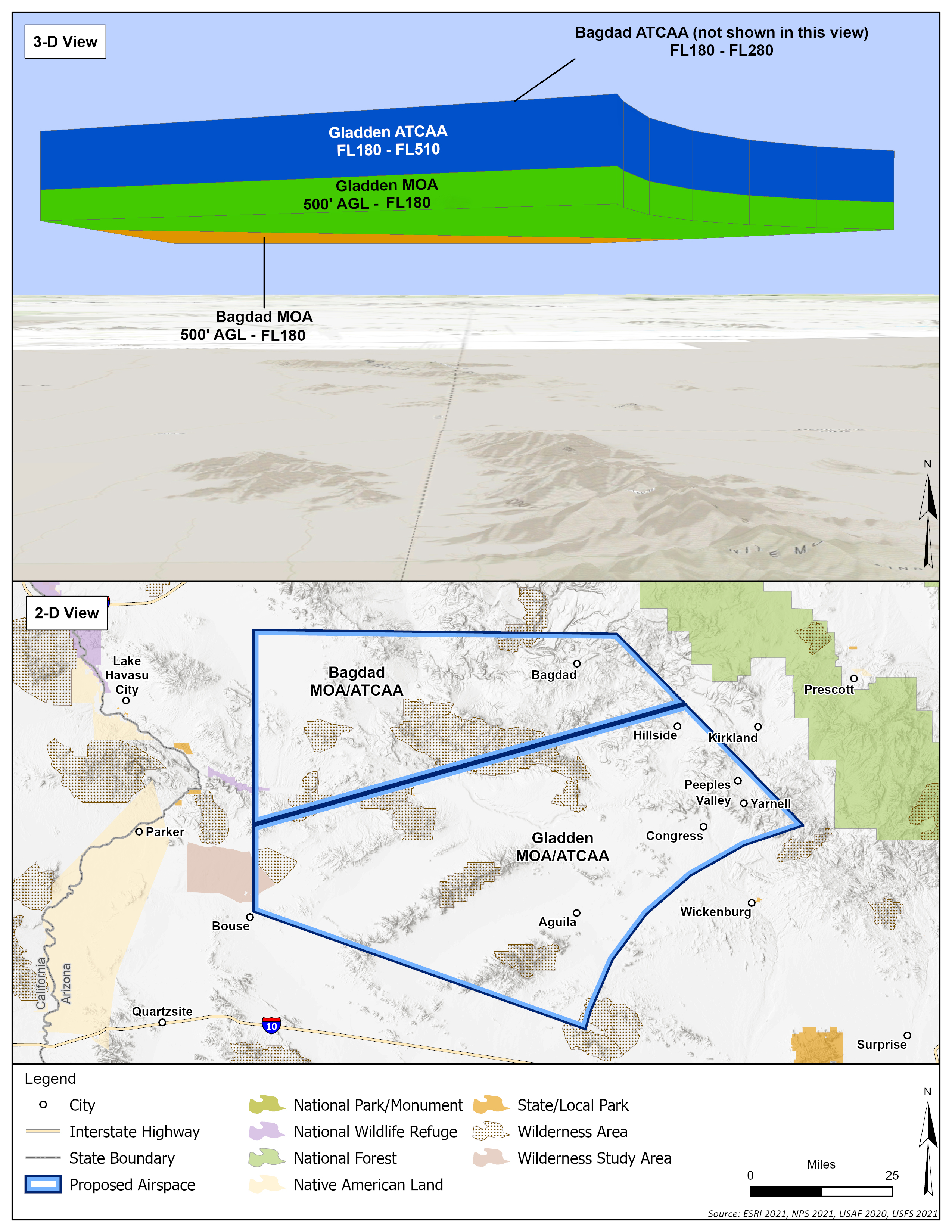
Bagdad and Gladden MOAs
Click on the figures below to view the existing airspace structure and the proposed changes by alternative. The table below the figures provides a summary of the existing attributes of the MOAs (Alternative 1 – No Action) and the proposed changes to the MOAs by alternative for comparison.
The proposed changes to these MOAs under Alternatives 2, 3, and 4 would include lowering the floor of both MOAs to 500 feet above ground level (AGL). Chaff and flares are currently used in both MOAs and would continue, but the minimum release altitude for flares would be reduced slightly to 2,000 feet AGL to align with the new lower floor. Supersonic flight is currently authorized above 10,000 feet mean sea level (MSL) and would continue under all alternatives.
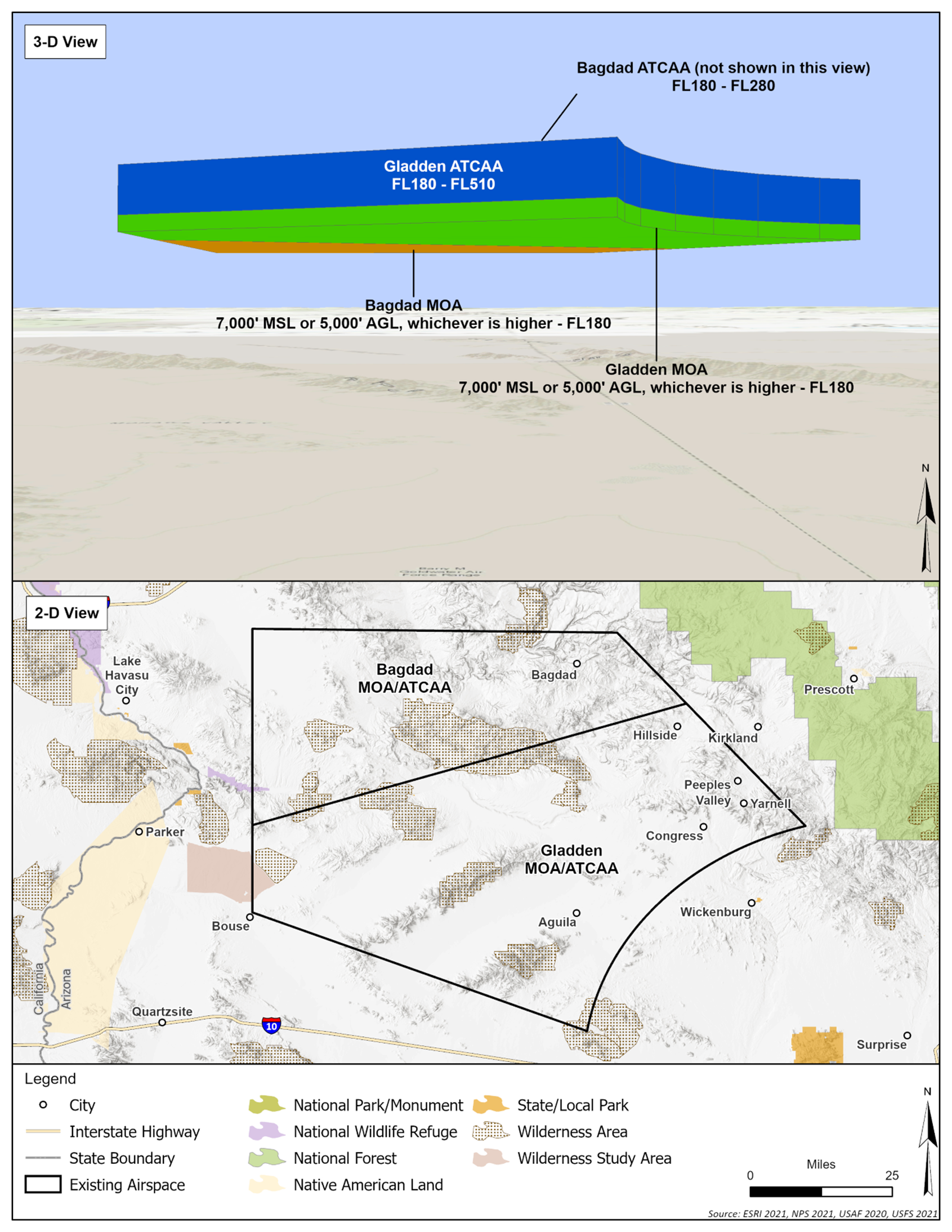
Alternative 1: No Action, Existing Airspace
Alternatives 2, 3 and 4
|
MOA |
Attributes and Operations |
Alternative 1 - No Action, Existing Airspace |
Alternatives 2, 3 and 4 |
|
Bagdad
|
Times of Use |
0600-1900 M-F; other times by NOTAM |
0600-2400 M-F, other times by NOTAM |
|
Horizontal Dimensions |
1,410 sqmi |
No change |
|
|
Vertical Dimensions |
7,000 feet MSL or 5,000 feet AGL (whichever is higher) to FL180 |
500 feet AGL to FL180 |
|
|
Chaff/Flare Authorization (minimum release altitude) |
Yes/Yes (5,000 feet AGL) |
2,000 feet AGL minimum release |
|
|
Supersonic Authorization |
10,000 feet MSL |
No change |
|
|
Annual Sorties2 |
6,920 |
9,120 |
|
|
Annual Supersonic Sorties3 |
4,498 |
6,019 |
|
|
Gladden
|
Times of Use |
0600-1900 M-F; other times by NOTAM |
0600-2400 M-F, other times by NOTAM |
|
Horizontal Dimensions |
2,476 sqmi |
No change |
|
|
Vertical Dimensions |
7,000 feet MSL or 5,000 feet AGL (whichever is higher) to FL180 |
500 feet AGL to FL180 |
|
|
Chaff/Flare Authorization (minimum release altitude) |
Yes/Yes (5,000 feet AGL) |
2,000 feet AGL minimum release |
|
|
Supersonic Authorization |
10,000 feet MSL |
No change |
|
|
Annual Sorties/Supersonic Sorties |
Used with Bagdad | ||
Legend: AGL = above ground level; FL = Flight Level; MSL = mean sea level; NOTAM = notice to airmen; M – F = Monday through Friday; sqmi = square miles
Notes:
1 Altitude references for aircraft operations are presented in several units of measure: AGL, MSL, and FL:
- AGL references are usually used at lower altitudes (almost always below 10,000 feet), when clearance from terrain is more of a concern for aircraft operation.
- MSL altitudes are used most across aviation when operating at or below 18,000 feet when clearance from terrain is less of a concern for aircraft operation.
- FL is used to describe the cruising altitudes for aircraft traveling long distances above 18,000 feet. Flight Levels are given in hundreds of feet, e.g. FL180 is 18,000 feet.
2 Annual sorties account for all based aircrews in Arizona and transients.
3 Supersonic speed does not occur for the duration of a sortie, but rather during one or more 30-60 second increments. The number of supersonic sorties is a subset of the Annual Sorties presented in the row above.