Sells, Ruby, Fuzzy MOAs
Click on the figures below to view the existing airspace structure. The table below the figures provides a summary of the existing attributes of the MOAs (Alternative 1 – No Action) and the proposed changes to the MOAs by alternative for comparison.
There are no proposed changes to the size or shape of these MOAs. There are also no changes to the supersonic authorization or in these MOAs. Under Alternatives 2, 3, and 4 the only change would be adjusting the published times of use for these contiguous MOAs to be consistent with each other and to align with how the MOAs are currently used. While there are no structural changes to Sells, Ruby, or Fuzzy MOAs, for analysis purposes, the number of sorties projected to occur in each MOA includes a 10 percent increase to account for fluctuations in training activity across all of the MOAs in the region. The projected total in each MOA was used in the Draft EIS analysis to provide an analysis of the possible highest use of any given MOA at a time.
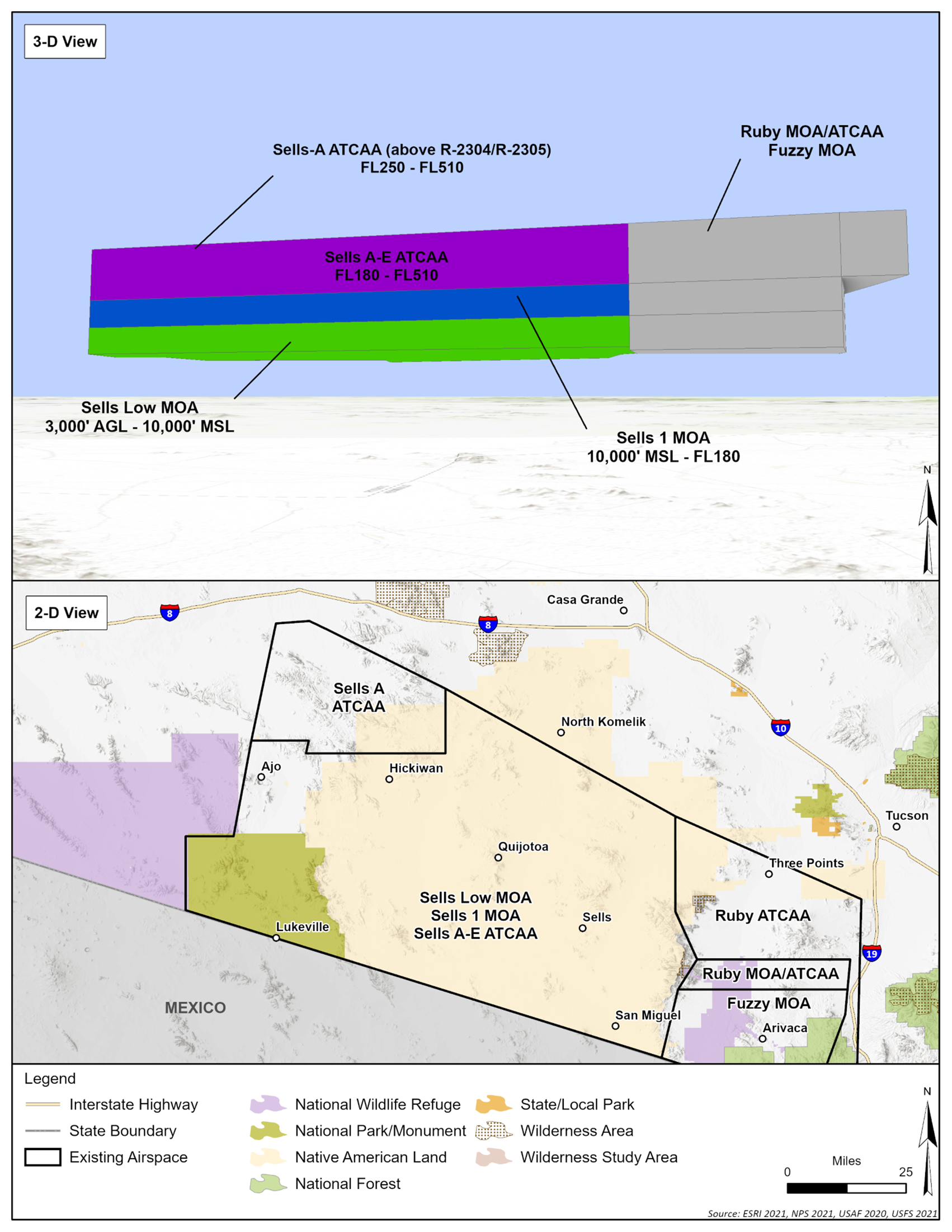
Sells MOA Existing and Proposed
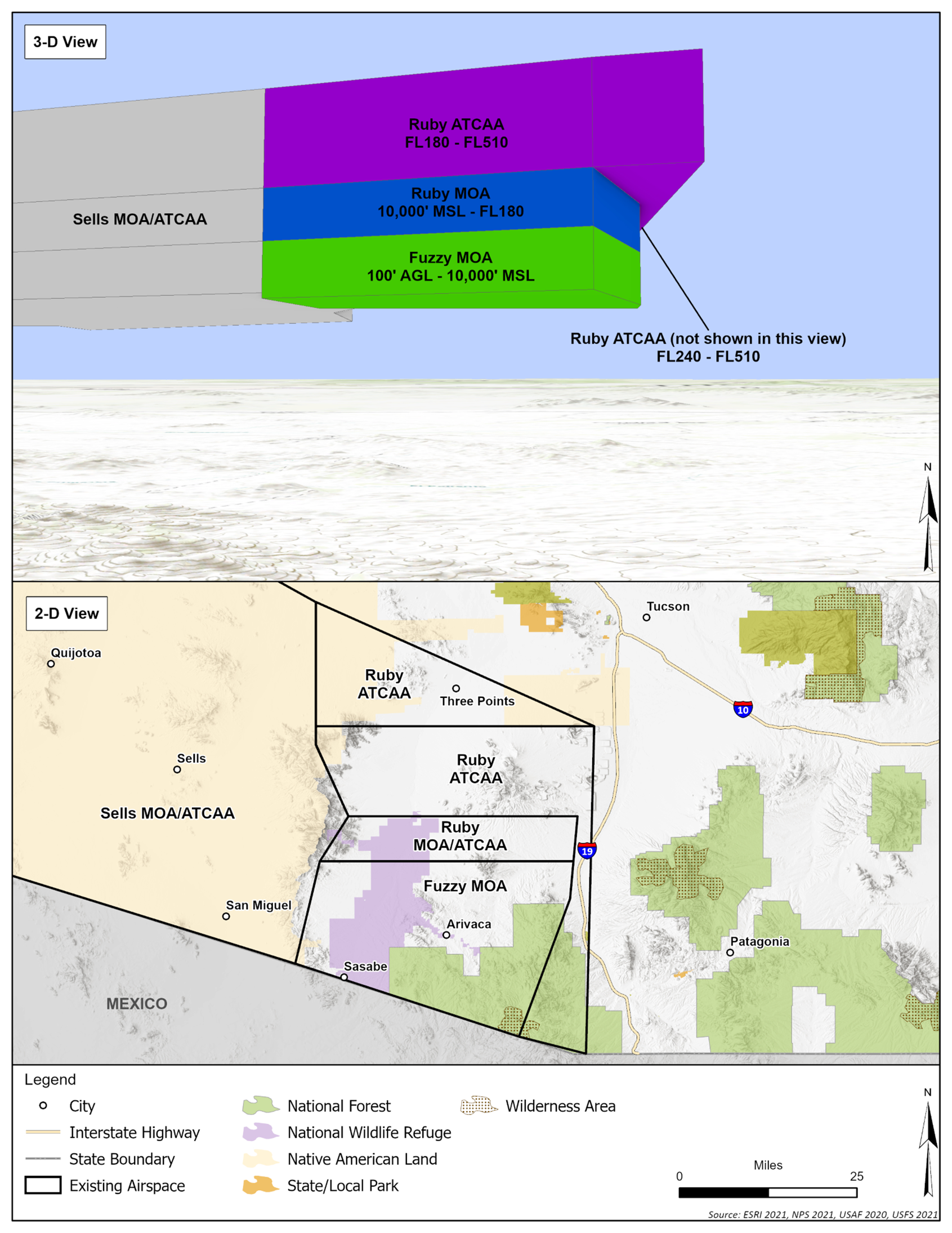
Ruby and Fuzzy MOA Existing and Proposed
|
MOA |
Attributes and Operations |
Alternative 1 - No Action, Existing Airspace |
Alternatives 2, 3 and 4 |
|
Ruby
|
Times of Use |
0600-1900 M-F; other times by NOTAM |
0600-2400 M-F, other times by NOTAM |
|
Horizontal Dimensions |
770 sqmi |
No change |
|
|
Vertical Dimensions |
10,000 feet MSL to FL180 |
No change |
|
|
Chaff/Flare Authorization (minimum release altitude) |
Yes/Yes (2,000 feet AGL) |
No change |
|
|
Supersonic Authorization |
Not authorized |
No change |
|
|
Annual Sorties2 |
5,490 |
7,610 |
|
|
Annual Supersonic Sorties3 |
0 |
0 |
|
|
Fuzzy
|
Times of Use |
0700-1900 daily; other times by NOTAM |
0600-2400 M-F, other times by NOTAM |
|
Horizontal Dimensions |
588 sqmi |
No change |
|
|
Vertical Dimensions |
100 feet AGL to 10,000 feet MSL |
No change |
|
|
Chaff/Flare Authorization (minimum release altitude) |
Yes/Yes (2,000 feet AGL) |
No change |
|
|
Supersonic Authorization |
Not authorized |
No change |
|
|
Annual Sorties/Supersonic Sorties |
Used with Ruby | ||
|
Sells
|
Times of Use |
0600-1900 M-F, other times by NOTAM |
0600-2400 M-F, other times by NOTAM |
|
Horizontal Dimensions |
4,854 sqmi |
No change |
|
|
Vertical Dimensions |
Low: 3,000 feet AGL to 10,000 feet MSL |
No change |
|
|
Chaff/Flare Authorization (minimum release altitude) |
Yes/Yes (3,000 feet AGL) |
No change |
|
|
Supersonic Authorization |
10,000 feet MSL |
No change |
|
|
Annual Sorties2 |
14,790 |
17,810 |
|
|
Annual Supersonic Sorties3 |
8,874 |
10,686 |
|
Legend: AGL = above ground level; FL = Flight Level; MSL = mean sea level; NOTAM = notice to airmen; M – F = Monday through Friday; sqmi = square miles
Notes:
1 Altitude references for aircraft operations are presented in several units of measure: AGL, MSL, and FL:
- AGL references are usually used at lower altitudes (almost always below 10,000 feet), when clearance from terrain is more of a concern for aircraft operation.
- MSL altitudes are used most across aviation when operating at or below 18,000 feet when clearance from terrain is less of a concern for aircraft operation.
- FL is used to describe the cruising altitudes for aircraft traveling long distances above 18,000 feet. Flight Levels are given in hundreds of feet, e.g. FL180 is 18,000 feet.
2 Annual sorties account for all based aircrews in Arizona and transients.
3 Supersonic speed does not occur for the duration of a sortie, but rather during one or more 30-60 second increments. The number of supersonic sorties is a subset of the Annual Sorties presented in the row above.