Tombstone MOA
Click on the figures below to view the existing airspace structure and the proposed changes by alternative. The table below the figures provides a summary of the existing attributes of the MOA (Alternative 1 – No Action) and the proposed changes to the MOA by alternative for comparison.
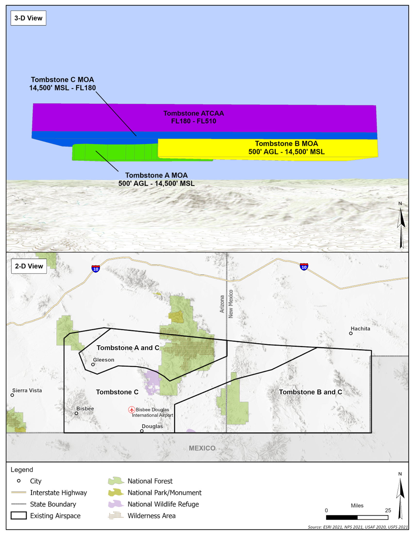
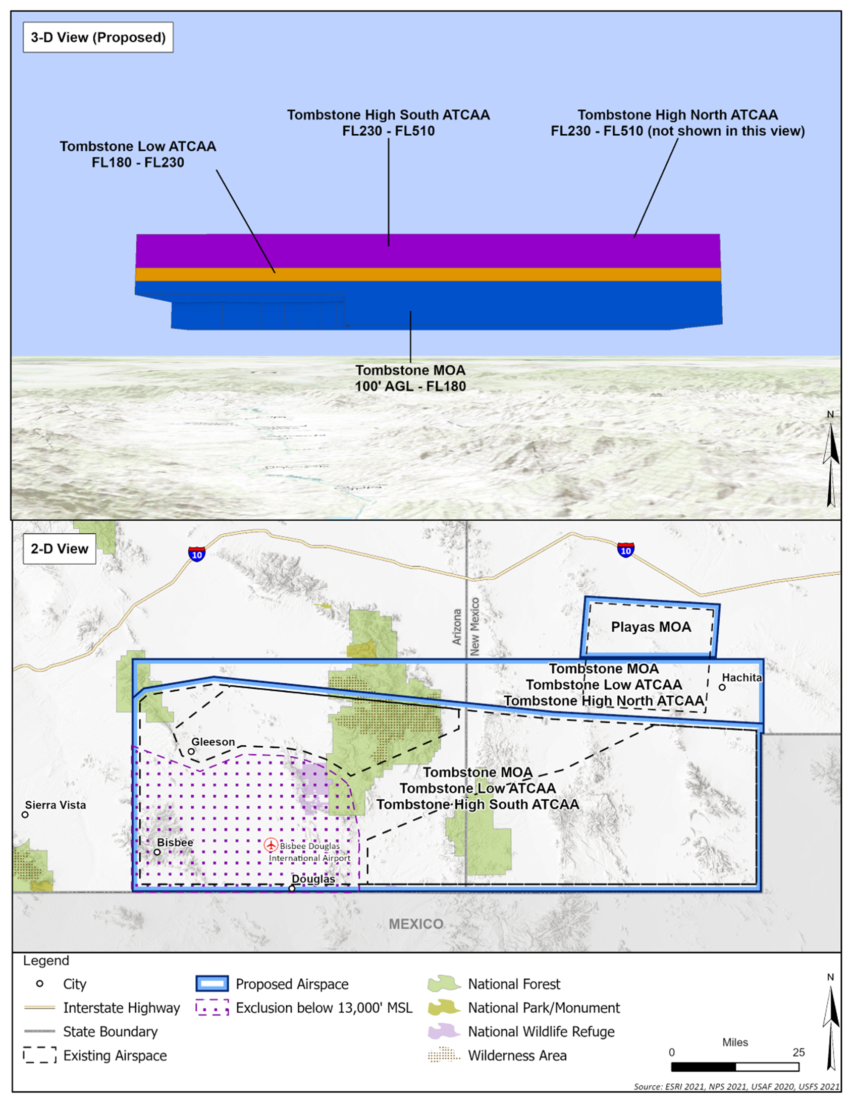
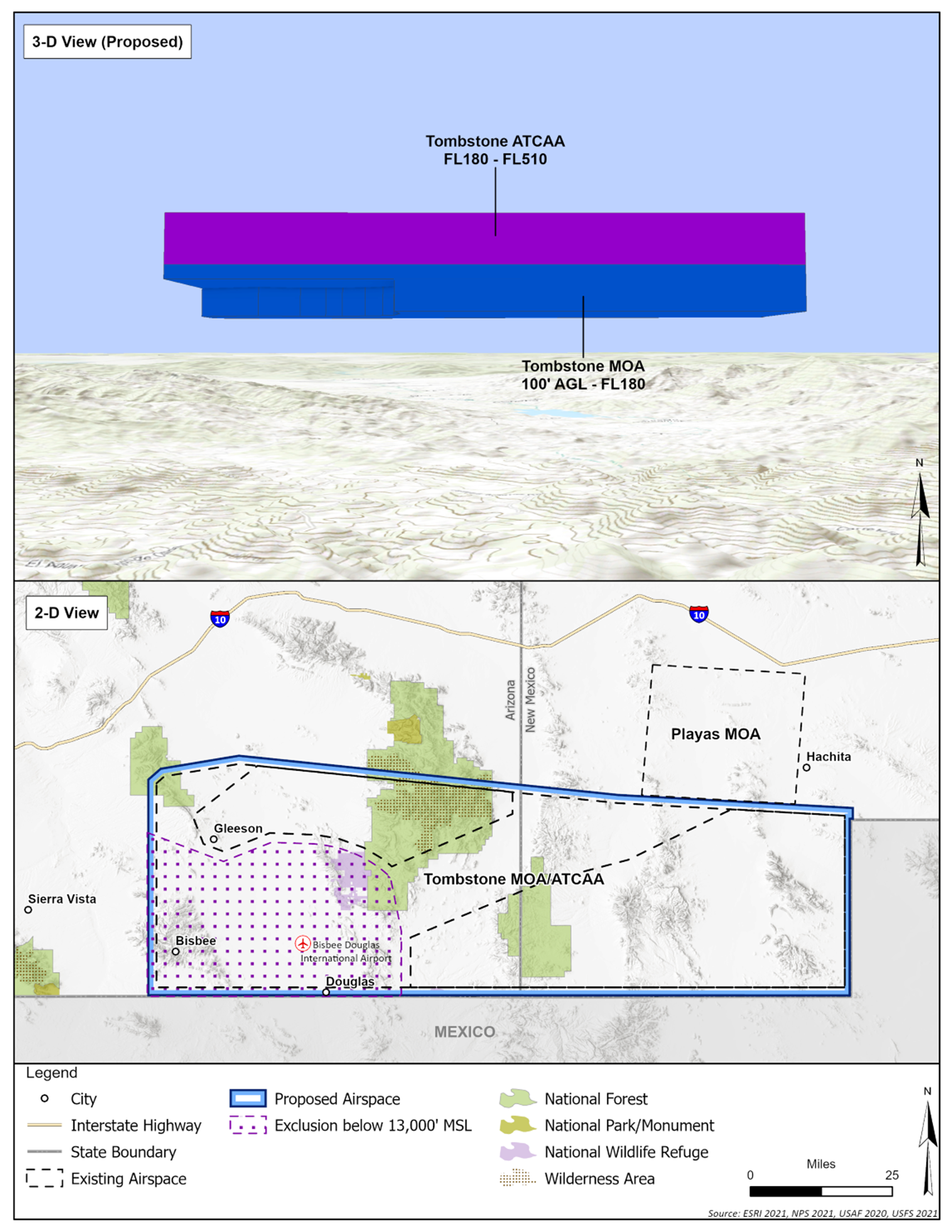
The current Tombstone MOA is broken up into three components (A and B which have floors of 500 feet above ground level (AGL) and C which exists over A and B at higher altitude). The proposed changes to this MOA under Alternative 2 would include combining these three areas into one space and lowering the floor to 100 feet AGL. The northern boundary would be moved approximately 10 nautical miles to the north to expand the area available for training. Additional changes under this alternative include authorizing supersonic operations down to 5,000 feet AGL, authorizing the use of chaff (which isn’t currently authorized), and lowering the minimum release altitude for flares to 2,000 feet AGL (currently the release altitude is 5,000 feet AGL).
Alternatives 3 and 4 are variations of Alternative 2. Under Alternative 3, all of the same changes as described above would be made except for the northern expansion. Under Alternative 4, all of the same changes as described above would be made except supersonic operations would be authorized down to 10,000 feet AGL.
Alternative 1: No Action, Existing Airspace
Alternatives 2 and 4
Alternative 3
|
Attributes and Operations |
Alternative 1 - No Action, Existing Airspace |
Alternative 2 |
Alternative 3 |
Alternative 4 |
|
Times of Use |
0600-2100 M-F; other times by NOTAM |
0600-2100 daily, other times by NOTAM |
||
|
Horizontal Dimensions |
3,968 sqmi |
4,766 sqmi |
No change |
4,766 sqmi |
|
Vertical Dimensions |
A and B: 500 feet AGL to 14,500 feet MSL |
Combine A,B,C: 100 feet AGL to FL180 |
||
|
Chaff/Flare Authorization (minimum release altitude) |
No/Yes (5,000 feet AGL) |
Authorize chaff; 2,000 feet AGL minimum release |
||
|
Supersonic Authorization |
30,000 feet MSL |
5,000 feet AGL |
10,000 feet AGL |
|
|
Annual Sorties2 |
3,450 |
8,000 |
6,900 |
8,000 |
|
Annual Supersonic Sorties3 |
0 |
80 |
69 |
80 |
Legend: AGL = above ground level; ATCAA = Air Traffic Control Assigned Airspace; FL = Flight Level; MSL = mean sea level; NOTAM = notice to airmen; M – F = Monday through Friday; sqmi = square miles
Notes:
1 Altitude references for aircraft operations are presented in several units of measure: AGL, MSL, and FL:
- AGL references are usually used at lower altitudes (almost always below 10,000 feet), when clearance from terrain is more of a concern for aircraft operation.
- MSL altitudes are used most across aviation when operating at or below 18,000 feet when clearance from terrain is less of a concern for aircraft operation.
- FL is used to describe the cruising altitudes for aircraft traveling long distances above 18,000 feet. Flight Levels are given in hundreds of feet, e.g. FL180 is 18,000 feet.
2Annual sorties account for all based aircrews in Arizona and transients.
3 Supersonic speed does not occur for the duration of a sortie, but rather during one or more 30-60 second increments. The number of supersonic sorties is a subset of the Annual Sorties presented in the row above.